120min maximum load 8kg multi rotor UAV Long120 with maximum speed 50km/h level 5 wind resistance light rain resistance
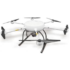
Long120 multi rotor UAV is a new integrated flight platform specially built for the map field. Long120 is a six axis multi rotor UAV with a wheelbase of 1.6m and a load of 8kg. It can run for 120 minutes with pure electric power; it has industrial level flight control, which can effectively deal with various harsh environments. By carrying different equipment, Long120 can be used in power line inspection, aerial survey, natural disaster survey, agriculture and forestry, land and resources, hydrological monitoring and other fields.
Main parameters of Long120
| Unfold wheelbase | 170cm |
| Dimension | 60*60*50 |
| Takeoff weight | 17kg |
| Maximum load | 8kg |
| Mission payload | 0-8kg |
| Maximum horizontal flight speed | 50km/h |
| Maximum ascent speed | 5m/s |
| Maximum descent speed | 3m/s |
| Max takeoff sea level | ≤2500m(standard package) ≤4500m(plateau package) |
| Max. wind resistance | ≤Level 5 |
| Rain resistance | Light rain |
| Operation temperature | -10℃——40℃ |
| Duration | 120min w/o payload |
| 65min with 6kg payload |
| Expandable payload | Photoelectric pod, SLR/oblique camera, infrared camera, LiDAR, multispectral / hyperspectral imager, detector, high altitude lighting |
| Expandable module | RTK/PKK,etc |
| Duration test environment | Altitude below 500m, temperature 15-30 ℃ (w/o load) |
| Inspection distance environment | No interference and shielding |
Main features of Long120
1. Pure electric: Long120 multi rotor UAV is equipped with super large capacity high-energy lithium battery as standard, which is simple to use and maintain and has high reliability.
2. Heavy load: The Long120 multi rotor UAV arm adopts a six rotor symmetrical layout design and is equipped with efficient motors and blades to effectively improve the efficiency of the power system and bring strong power. The integrated carbon fiber fuselage can support a maximum load of 8kg, and the duration time is longer than 55 minutes. It can meet the needs of long-time operation of heavy load equipment.
3. Long duration: Thanks to the excellent aerodynamic layout design and efficient power system of Long120 multi rotor UAV, it ensures not only the most efficient operation of pneumatic and power system, but also brings a long endurance of up to 120min. The biggest benefit of long duration is to improve work efficiency and economic benefits.
4. Multi load and multi task: Long120 multi rotor UAV adopts modular task load design and multi-source data acquisition scheme. It can be equipped with LiDAR, visible light video load, thermal infrared video load, orthophoto load, oblique photography load, thermal infrared remote sensing load, etc. to generate orthophoto map, 3D map and thermal infrared remote sensing map, so as to meet the requirements of diversified data acquisition.
5. Strong environmental adaptability: Long120 multi rotor UAV adopts an integrated carbon fiber body. The solid carbon fiber body is suitable for changeable weather and climate and can resist the interference of level 5 wind and snow. It can work normally even in light rain to meet the requirements of emergency tasks in extreme environments.
Industry application of Long120
Taking UAV as the flight platform, multiple types of data can be obtained by carrying orthophoto camera, multispectral camera, oblique camera, thermal infrared camera and LiDAR. It is widely used in disaster emergency and treatment, land supervision and resource development, especially in basic mapping, land resource investigation and monitoring, land use dynamic monitoring, emergency relief mapping, the investigation of forestry resources and forest fire prevention.
1. Application of visible light remote sensing by UAV in forest resource parameter extraction
2. Application of UAV equipped with multispectral sensors in forestry resources investigation and water quality monitoring
3. Application of UAV oblique Photogrammetry in large-scale topographic mapping
4. Application of UAV equipped with thermal infrared sensor in forest fire prevention
5. Application of UAV airborne LiDAR in topographic mapping
6. Application of UAV and airborne LiDAR in forestry investigation